
And what is a Safe System?
Today, 60% of PAUSD middle and high school students walk and bike to school, and Palo Alto is one of the top five U.S. cities with a 60k+ population for bicycle commuting. Yet, Palo Alto does not yet have a road safety policy in place to protect these and other vulnerable road users. To improve road safety the City of Palo Alto could adopt a Safe System policy for road safety and set an ambitious timeline for pursuing the city’s goal of zero severe injuries and roadway fatalities on streets in Palo Alto.
The central premise of a Safe System approach is the recognition that:
As humans, we are all vulnerable to injury and make mistakes. However, no one should be seriously injured or worse on the road as a result of these mistakes.
As shown in the table below, this leads to a different approach to safety:
| Traditional approach | Safe System approach |
|---|---|
| Only improve safety after a severe crash has happened | Don’t wait for tragedy to happen; apply known safety principles proactively and systematically |
| Responsibility for safety rests with the user | The road owner is also responsible for safety |
These Safe System safety principles would be applied to any repaving or new infrastructure project:
Mono-Functionality: Crashes are more likely to occur on Residential Arterial and Arterial streets that serve both through traffic and local traffic. Examples in Palo Alto include El Camino Real, Middlefield, Alma, and University Avenue between El Camino and Middlefield. Ideally, these types of streets serve either a traffic flow or local exchange function, but not both. The City of Palo Alto already has policies in place to limit through traffic on local streets. Improving road safety on arterials would include eliminating street parking, driveways, and unprotected left turns whenever possible, and building (protected) bike lanes.
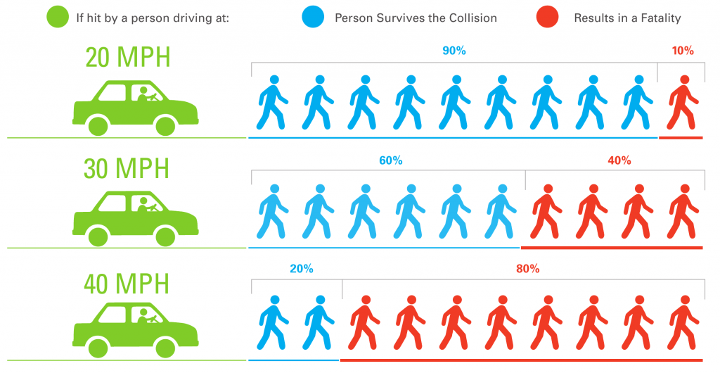
Safe Speeds: The figure below shows that at vehicle speeds higher than 20 mph the risk of death in a crash for pedestrians (and bicyclists) dramatically increases. When cars, pedestrians, and bicyclists share the road, ideally the speed limit should be 20 mph. At higher speeds there should be separate (protected) infrastructure for bicyclists and pedestrians.
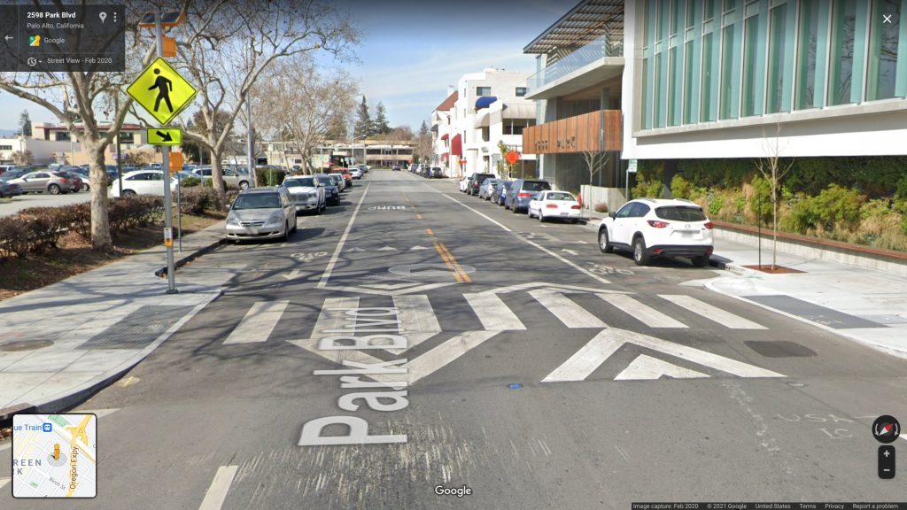
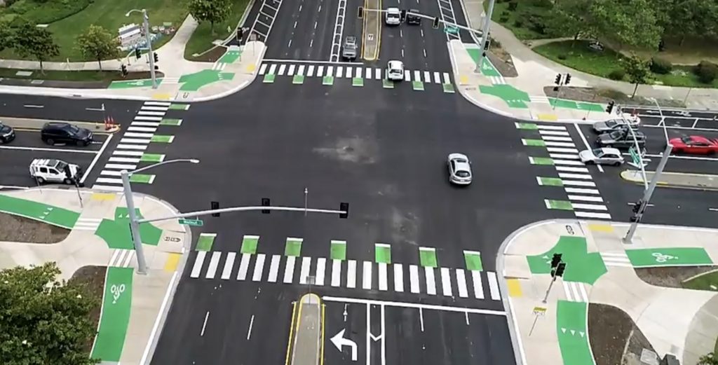
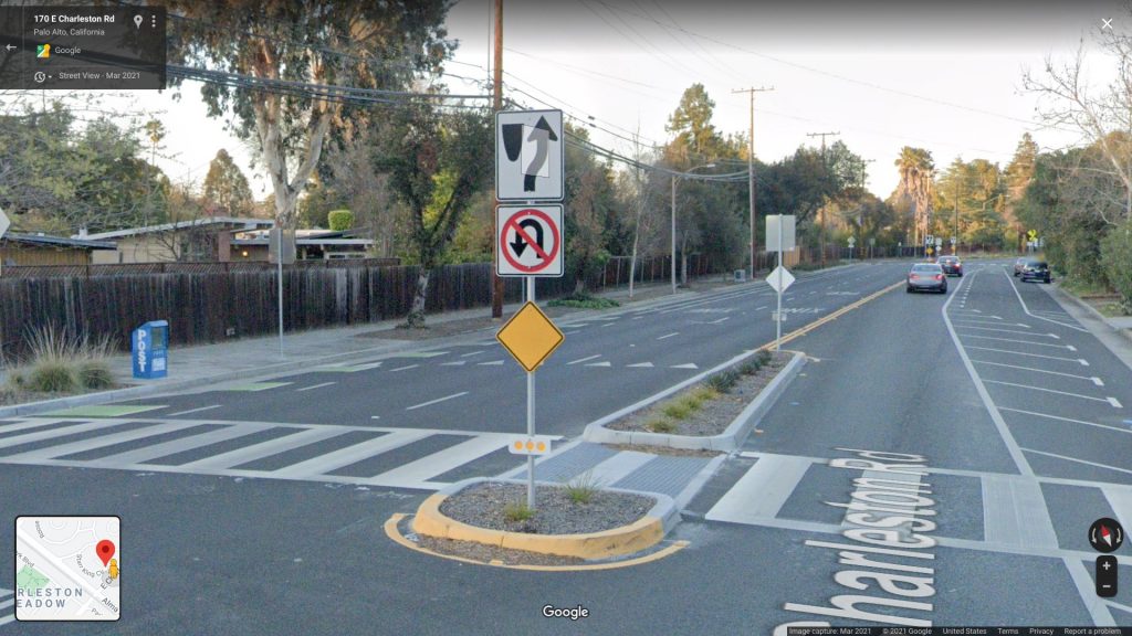
Self-explaining road: A self-explaining road is a traffic environment which elicits safe behavior simply by its human centered design. For example, a driver may intuitively drive slower and more cautiously if the road is narrow or has limited forward visibility. The self-explaining road also makes it easier for users to know where to walk, ride, drive, and park. Examples include: using green paint to identify bicycle infrastructure, paving parking lanes with a different material than the driving lane, and installing bulb outs at intersections to prevent drivers from parking too close to the intersection and thus limiting visibility.
What could this look like in Palo Alto?
In addition to the above working principles, a road safety policy for Palo Alto could include items such as:
Safe System Assessment. The City could develop an assessment matrix that can be used to objectively evaluate how well repaving and new infrastructure projects meet the above Safe System principles.
Post-Crash Engineering Investigation. Currently, after a severe or fatal crash the City completes a police report and engineers come out to evaluate whether the road is up to code. We ask that the City conduct a more comprehensive evaluation to determine, beyond mere code compliance, what additional steps can be taken to make the road in question safer and to avoid future crashes. This investigation should be made available to the public.
Prioritize High Frequency Collision Corridors. The 2012 Bicycle and Pedestrian Transportation Plan identified 14 high frequency bicycle and pedestrian collision locations. As of this writing, only the locations Embarcadero Road/Middlefield Road and Foothill Expressway/Arastradero Road have seen some safety improvements completed. Work is ongoing, planned, or on hold along the Charleston/Arastradero corridor, Page Mill Road, Alma Street/Churchill Avenue, and El Camino Real/Embarcadero Road. This means that 7 out of 14 of these locations have not received any attention in the past decade. We ask that the City more expeditiously address these remaining and similar locations.
Pursue the goals of zero severe injuries and roadway fatalities with an ambitious target date. Palo Alto’s Comprehensive Plan already contains policy T-6.2 “Pursue the goal of zero severe injuries and roadway fatalities on Palo Alto city streets.”, but it has not identified a particular target date to achieve this goal. We believe that this work requires more urgency and that we need to set an ambitious timeline for achieving zero fatalities and severe injuries on streets in Palo Alto.
Periodic policy updates. According to Caltrans, road safety policies should be updated every 5 years to evaluate their performance.
Some examples of infrastructure that would be promoted by a Safe System approach include:
More information on road safety in Palo Alto can be found in this report.